NREC is pioneering research and development of a low power, small, lightweight system for producing accurate 3D maps of tunnels through its Precision Tunnel Mapping program.
Producing accurate 3D models of underground mines and tunnels is challenging due to their great variability and lack of salient structure or appearance features, and because GPS will not function underground.
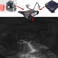
Building from two decades of experience in developing and testing a variety of robotic localization, mapping and autonomy systems, NREC is developing a new low power, small and lightweight system for mapping tunnels for use in border control, defense and underground mining applications. This program constructs high quality 3D maps by building on currently deployed mine mapping technology that fuses stereo visual odometry with lidar-based localization. It also supports real-time 3D teleoperation with commercial-off-the-shelf (COTS) computing hardware.
The developed technology produces accurate maps of challenging zero light environments. It can be integrated with small robots such as the Counter Tunnel Exploitation Robot (CTER) developed by Raytheon Sarcos or the iRobot Packbot. It can also be used in outdoor or indoor environments.