Riverine Mapping
Associated Lab:
Field Robotics Center (FRC)
This Project is no longer active.
This Project is no longer active.
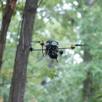
This project is developing technology to map riverine environments from a low-flying rotorcraft. Challenges include dealing with varying appearance of the river and surrounding canopy, intermittent GPS and a highly constrained payload. We are developing self-supervised algorithms that can segment images from onboard cameras to determine the course of the river ahead, and we are developing devices and methods capable of mapping the shoreline.
Displaying 4 Publications
current head


current contact
past staff
- Lyle J. Chamberlain
- Andrew D Chambers
- Sezal Jain
- Bernd Manfred Kitt
- Joern Rehder